• About
  • Work
  • Maps
  • Writing
  • Strange Borders
Menu

am proehl

  • About
  • Work
  • Maps
  • Writing
  • Strange Borders
Russia-USA, Diomede Islands Map.png

A Map of the USA / Russia Border as it Passes Between the Diomede Islands

June 24, 2018

The Diomede Islands lie in the middle of the Bering Strait between Russia and the United States. Though the two islands are only about 2.4 miles apart and clearly a single group, they are separated by the International Dateline which also marks the international border between Russia and the United States. Big Diomede is owned by Russia and Little Diomede is owned by the USA. They are sometimes called Tomorrow and Yesterday respectively because they straddle the dateline.

Their official separation into Russian and US Territiories was set by the 1867 treaty finalizing the sale of Alaska by Russia to the United States. That treaty includes the text,

"The western limit within which the territories and dominion conveyed, are contained, passes through a point in Behring's straits on the parallel of sixty-five degrees thirty minutes north latitude, at its intersection by the meridian which passes midway between the islands of Krusenstern, or Ignalook, and the island of Ratmanoff, or Noonarbook, and proceeds north, without limitation, into the same Frozen Ocean."

The treaty references Krusenstern and Nunarbuk which were alternative Russian names for the islands as well as names used but the local native population. There is a small Inupiat Eskimo population on Little Diomede Island in a small village on its Western shore. Big Diomede has a small Russian Military population but the native population on Big Diomede was relocated to the mainland by Russia.

The islands gained a bit of unexpected fame during the 2008 US Presidential Election. Although you really can see Russia from Alaska here, it became the subject of a Saturday Night Live satire with Tina Fey playing the role of Sarah Palin in her less than successful bid for the Vice President.

Sources: Wikipedia , Library of Congress

Tags water, island, international-date-line
Comment
Kenya-Uganda, Migingo Island Map.png

A Map of the Uganda / Kenya Border Dispute Over Migingo Island

June 24, 2018

I expect this map to change over the next few days as it is the best representation I could make after reading many stories and reviewing a bunch of maps on the Internet.

Uganda and Kenya have been arguing over who owns the small island, barely visible at the center of the map above. The dispute has been brewing over the last few years and has finally led to a joint survey that is being conducted this week by both countries with results expected as soon as this week (May 15th). As far as I can tell, the dispute comes down to whether the islands are East or West of the Western tip of Pyramid Island just to the South. Pyramid Island is referenced in the constitutions of both countries. From the Western shore of Pyramid Island, the border line continues North to another island. If the shores of Migingo Island are West of that line then the island is in Uganda, otherwise, they are in Kenya.

I have drawn the islands as being just barely in Kenya as the most recent press and other descriptions seem to be leaning towards a situation where the island is in Kenya but the water just West of the Island is in Uganda. This would be ironic because the source of the dispute is fishing rights over the dwindling Nile Perch that are still in abundance around the island.

The island was uninhabited until at least 1991 when two Kenyan fisherman say they set up residence. Uganda says that a Ugandan fisherman started living on the island in 2004 and had found the island abandoned. The island is about half the size of a football field and barely above water. It may have even been below water in previous years when the waters of Lake Victoria were higher. It is amazing to see the island itself because it is basically a large rock with a bunch of tin hacks that house the islands 1000 or so residents. There is barely any open space on the island.

I plan to update the map once the surveyors complete theirs. Apologies in advance for any inaccuracies but I wanted to get the story out while it is still unfolding.

Tags disputed, water-rights, water
1 Comment
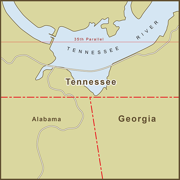
Georgia-Tennessee, Water Border Map.png

A Map of the Georgia / Tennessee Border Dispute Over Water Rights

June 24, 2018

There are many historians and economists who say that the battles of the future will be fought over water not oil. Though only a battle of words, one is already occurring between Georgia and Tennessee.

The original border between the two states was supposed to be drawn along the 35th Parallel. The actual border that was staked out was about a mile south of the where it was supposed to be. Stories differ as to why this happened. One postulates that the line where the border should have been drawn was difficult terrain so the survey crew marked the line on more navigable land. I love stories of human error so this is the story I want to believe but this can't be the first time a crew had to mark a line across challenging terrain. The other theory attributes the mistake to a simple matter of instrument accuracy. Whatever the case, the border was staked out and a map was drawn with the border more or less where it lies today.

The error was eventually caught but by then the wrong border had been around long enough that it had become the accepted state line. The border issue is being raised now because Georgia has a water shortage. If the border had been drawn accurately, a small part of the Tennessee River would lie inside Georgia, giving it access to much more water than it has today. Atlanta is sometimes called, "The Las Vegas of the American Southeast" for its habit of living beyond its means when it comes to water.

Georgia politicians have made numerous attempts to resolve the border issue with Tennessee ("in the 1890s, 1905, 1915, 1922, 1941, 1947, 1971" and 2008 according to one source). But such a change would require approval from Congress and Tennessee... something that's unlikely to happen. Moving the border would solve Georgia's problems but would create new ones. A Washington Post article reported on two issues that Georgia does not seem to bring up in its proposal, "Not only would Georgia get a chunk of Chattanooga, but Mississippi would get a slice of Memphis."

Perhaps the best quote on the border issue came from a contemporary Georgia surveyor, Bart Crattle who said, "It's correct -- no matter how wrong it is."

Sources: Wikipedia , Washington Post , NY Times

Tags water, water-rights, human-error
1 Comment
China-Japan, Senkaku Islands Map.png

A Map of the Senkaku Islands Territory Dispute Between China and Japan

June 24, 2018

Only the discovery of fossil fuels would make two countries argue over what had previously been described as "terra nullius" (vacant territory), and "barron rocks". The Senkaku Islands are made up of 8 land masses... five uninhabited islets and three rocks. What lies underneath is what makes them suddenly so interesting.

The islands lie 120 nautical miles west of Okinawa and North East of Taiwan. The dispute is primarily between Japan and China but China needs the proximity and history of Taiwan to bolster it's claim so Taiwan is part of the dispute by proxy.

The earliest recorded reference to the Islands seems to come from China. There is even a Japanese map that shows the islands as Chinese territory. Japan claims the islands as spoils from the 1895 Treaty of Shimonoseky it signed with China after the First Sino-Japanese War. China's claims originate from the Treaty of San Francisco which was signed by Japan and the Allies after World War II and rendered the Treaty of Shimonoseky null and void.

After WWII, the United States administered the Senkaku Islands until 1972 when it handed administrative control over to Japan along with Okinawa. China's (and Taiwan's) renewed interest in the islands started in 1970 (coincidentally just two years after the potential for oil was discovered). The dispute continues and the islands have had a regular presence in the news as an Asian flashpoint. The United Nation's "Law of the Sea" gives nations control over a 200 nautical mile "exclusive economic zone" (EEZ) surrounding their territory. EEZ's include seabed and submarine resources like oil and natural gas. The border in the lower right and encompassing everything above it on the map is China's EEZ claim and extends out from Taiwan's border to the south-west. The border in the top left is Japan's EEZ claim and extends out from the (undisputed) islands in its Okinawa prefecture.

Not willing to wait till the matter is formally resolved, China built a natural gas drilling platform outside of Japan's claimed territory but which is capable of drilling into the disputed area to extract gas. Skirmishes and posturing continue including altercations between Chinese, Taiwanese and Japanese ships circling the islands to assert their claims.

Although Senkaku is the Japanese name for the group of islands, China refers to them as the Diaoyo Islands. Diaoyu and the Japanese name for Uotsuri, the largest island translate as, "Fishing".

Sources: Wikipedia , Christian Science Monitor , The Guardian

Tags water, disputed
Comment
Canada-Denmark, Hans Island Map.png

Border Dispute with a Sense of Humor - A Map of the Canada / Denmark Border at Hans Island

June 24, 2018

Hans Island lies smack in the middle of the Kennedy Channel section of Nares Strait. This places it on the border between Canada's Ellesmere Island and the Kingdom of Denmark's Greenland Territory.

In 1973, a treaty between the two nations plotted 127 points delimiting the agreed upon border. Although the treaty did not connect the dots, points 122 and 123 go right down the center of the island when connected.

Hans Island appears to be of little strategic or commercial interest but this has never stopped nations from starting a tug of war over sovereignty. Luckily, even though there are real emotions, the actions seem to be light hearted, if not satirical.

In 1984, Denmark's Minister of Greenland planted a Danish Flag on the island along with a bottle of cognac.

Canada responded with newspaper headlines announcing, "Canada being invaded" and "Denmark massing troops on Canadian Territory"

Google War - In 2005, a "Google War" was started with individuals from both countries placing ads on Google declaring Hans Island as Canadian or Danish territory.

The ads are no longer live but a Google search today turned up links for, "The Hans Island Liberation Front", "Hands off Hans Island", "Radio Free Hans Island", and the "Free Hans Island from Canadian Oppression" website. The last link is a fun read.

It's nice to see a lingering border dispute happen with a sense of humor.

Tags water, funny
Comment

The Border Between Egypt and Sudan at the Wadi Halfa Salient

June 24, 2018

Do you see the 52 villages in the map? No? That's because they were flooded by the damning of the Nile and the creation of Lake Nasser (known as Lake Nubia in Sudan). The strange bulge (known as a salient in cartography parlance) along this portion of the Egypt-Sudan border was originally surrounded the villages that dotted this section of the Nile.

Egypt and Sudan have 3 areas of land under dispute and a fourth that neither country claims. The original 1899 border between the two countries ran straight along the 22nd North Parallel line with no deviations. In 1902, Britain amended the border to account for some tribal and administrative issues. There were 52 villages where the Nile River crossed the 22nd Parallel. It was decided that these villages would be easier to maintain from the Sudanese side of the border so the border was changed to how it appears above. There appears to be a stretch of rough and desolate terrain North of this area that separates it from the next set of villages in current maps.

Egypt now claims this area along with the other two areas (Bir Tawil and the Hala'ib Triangle) in dispute. They maintain a military presence in the other two but not here as there is little of interest to guard.

Sources: Wikipedia 

Tags water
Comment

A Map of the Border Dispute Between China and South Korea Over Socotra Rock

June 24, 2018

I debated what to draw for this map for reasons that will become clear. In the end, I decided to show only water because Socotra Rock, the focus of this dispute lies about 18 feet under water even at low tide) and the nearest borders are miles away. It is the first land dispute I’ve come across with no land involved. For a rock that rarely appears above water, it sure does have a lot of names. South Korea knows it as Leodo or Parangdo whereas China calls the rock, Suyon. Socotra, the commonly accepted name, comes from the British Ship that first “discovered” and charted the rock (more as a navigational hazard than a landmark).

Both the Peoples Republic of China and South Korea claim the rock. By objective measures, it lies closer to Korean territory at roughly 93 miles from the island of Marado (near the much larger Jeju Island). Sucotra Rock lies approximately 178 miles away from China's nearest island, Yushandao, almost double the distance between Korea and the rock. In the late 1990’s, Korea built a helipad and “Ocean Research Station” directly over the rock. Here is an image of the station.

Wikipedia claims that China later burned that station down in a raid. I was hoping to be able to see something in a satellite view on Google Maps but I think the rock is too small and insignificant to be covered by their images.

Coordinates: 32°07′22.63″N 125°10′56.81″E.

Tags water
1 Comment

Latest Posts

Featured
Mar 22, 2020
A Map of the 'Southwick Jog' between Massachusetts and Connecticut
Mar 22, 2020
Mar 22, 2020
Jun 24, 2018
The Property Border in Seattle that was Forced to go Around Edith Macefield’s House
Jun 24, 2018
Jun 24, 2018
Jun 24, 2018
The strange, slavery-defined border of Oklahoma’s Panhandle
Jun 24, 2018
Jun 24, 2018
Jun 24, 2018
Entrepreneurial Strangeness, A Map of the French-Swiss Border at the Hotel Arbez
Jun 24, 2018
Jun 24, 2018
Jun 24, 2018
The Strange Border between Croatia and Serbia in Liberland
Jun 24, 2018
Jun 24, 2018
Jun 24, 2018
A Map of the Bir Tawil "Triangle" and Related Territory Dispute Between Egypt and the Sudan
Jun 24, 2018
Jun 24, 2018
Jun 24, 2018
A Map of the Louisiana / Mississippi State Border along the Mississippi River
Jun 24, 2018
Jun 24, 2018
Jun 24, 2018
A Map of the USA / Russia Border as it Passes Between the Diomede Islands
Jun 24, 2018
Jun 24, 2018
Jun 24, 2018
A Map of the Uganda / Kenya Border Dispute Over Migingo Island
Jun 24, 2018
Jun 24, 2018
Jun 24, 2018
A Map of the Slovenia / Croatia Border as it Passes Through the Middle of Restaurant Kalin in the Town of Bregana
Jun 24, 2018
Jun 24, 2018

All maps are copyright 2018 by Andy Proehl