• About
  • Work
  • Maps
  • Writing
  • Strange Borders
Menu

am proehl

  • About
  • Work
  • Maps
  • Writing
  • Strange Borders
Russia-USA, Diomede Islands Map.png

A Map of the USA / Russia Border as it Passes Between the Diomede Islands

June 24, 2018

The Diomede Islands lie in the middle of the Bering Strait between Russia and the United States. Though the two islands are only about 2.4 miles apart and clearly a single group, they are separated by the International Dateline which also marks the international border between Russia and the United States. Big Diomede is owned by Russia and Little Diomede is owned by the USA. They are sometimes called Tomorrow and Yesterday respectively because they straddle the dateline.

Their official separation into Russian and US Territiories was set by the 1867 treaty finalizing the sale of Alaska by Russia to the United States. That treaty includes the text,

"The western limit within which the territories and dominion conveyed, are contained, passes through a point in Behring's straits on the parallel of sixty-five degrees thirty minutes north latitude, at its intersection by the meridian which passes midway between the islands of Krusenstern, or Ignalook, and the island of Ratmanoff, or Noonarbook, and proceeds north, without limitation, into the same Frozen Ocean."

The treaty references Krusenstern and Nunarbuk which were alternative Russian names for the islands as well as names used but the local native population. There is a small Inupiat Eskimo population on Little Diomede Island in a small village on its Western shore. Big Diomede has a small Russian Military population but the native population on Big Diomede was relocated to the mainland by Russia.

The islands gained a bit of unexpected fame during the 2008 US Presidential Election. Although you really can see Russia from Alaska here, it became the subject of a Saturday Night Live satire with Tina Fey playing the role of Sarah Palin in her less than successful bid for the Vice President.

Sources: Wikipedia , Library of Congress

Tags water, island, international-date-line
Comment
Finland-Sweden, Market Island Map.png

A Map of the Strange Border Between Sweden and Finland on Märket Fyr

June 24, 2018

How did I not hear about this border sooner. An island less than 1200 feet long with a border that takes more twists and turns than a Stieg Larsson novel. It is now possible to walk the length of this short island and cross an international border three times. However, despite the strangeness of the border, Sweden and Finland have always agreed on shared ownership of the skerry (a Norse word for rock in the sea) and the serpentine border results from an effort to correct Finland's accidental siting of the island's lighthouse on the Swedish side of the border. The island is otherwise a textbook example of international cooperation and agreement.

Market Island or Reef (Market Fyr in Swedish) is part of the larger Aland Island chain that lies between Sweden and Finland. According to Wikipedia, ownership of the islands has been shared ever since the Treaty of Fredrikshamn in 1809. Prior to the building of the lighthouse, the border between the two countries passed down the middle of the skerry so that half the island's land mass was in Sweden and half was in Finland. When it was discovered that Finland had accidentally built the lighthouse on Sweden's half of the island, a fix was necessary. The resulting zig-zag border allows the lighthouse to be in Finland while retaining the 50/50 split in land area and avoids any changes to the maritime border. Any alterations of that would have resulted in a change in fishing rights… Perhaps the one thing that might have caused strife between the two herring-loving nations. Phew.

Tags island, funny
Comment
NY-NJ, Ellis Island Map.png

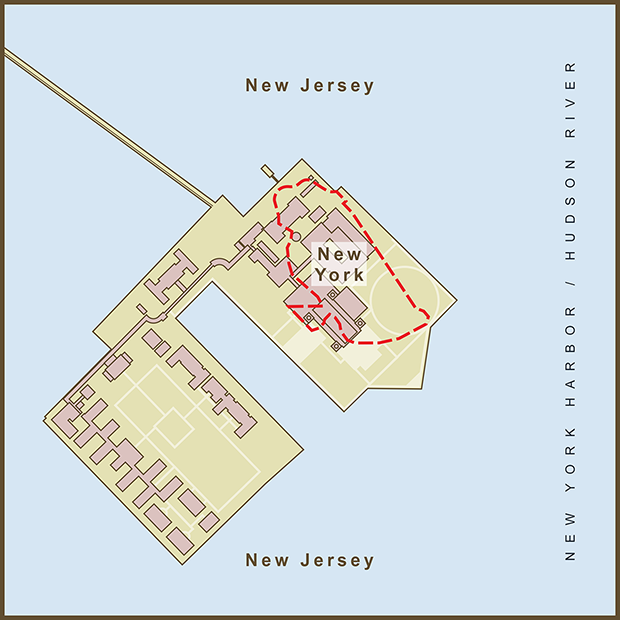
A Map of the Border Between New York & New Jersey on Ellis Island

June 24, 2018

For so many immigrants, stepping off a ship onto Ellis Island was synonymous with arrival in New York City. Many years later, after the immigration station had closed and the buildings lie decaying, the US Supreme Court would decide that Ellis Island, with one small exception, was part of New Jersey.

The original colonial land grant for New Jersey defined it's border as the waterline of New York Bay and the Hudson River, meaning that the water and all islands within it belonged to New York. Most treaties place borders in the middle of natural borders like lakes and rivers. New Jersey tried to fight the claim starting in the early 1800s. In 1834 a compact between New York and New Jersey and ratified by the US Congress set the border as the middle of the Hudson River. This put jurisdiction and bragging rights over the island completely in New Jersey which they were quick to assert and claim in a court filing. The case went all the way up to the Supreme Court. New York fought hard but in the end was awarded only the small 3.3 acre section of the original island. Since that border follows the island's original shoreline it appears quite random today and passes through the middle of numerous buildings. The majority of the current island (most of it created by landfill from the digging of New York City subway tunnels) is now officially part of the State of New Jersey. Payback for Jersey's actions and perhaps the best argument for custody came from then Mayor Rudy Giuliani who remarked that his Italian father "never intended to emigrate to New Jersey."

In the pre-colonial days, Ellis Island was one of several, oyster-rich islands on the western tidal flats of Upper New York Bay. Other nearby islands included Liberty Island (originally Bedloe's Island and site of the Statue of Liberty) and Black Tom Island (named after an African-American that lived on the island according to local legend). Before becoming known as Ellis Island, it had been known as Dyre's Island, Bucking, Gibbet (Gibbet's being cages for displaying the dead bodies of convicted pirates), and lastly, Little Oyster Island. Samuel Ellis acquired the island during the American Revolution and first tried to sell it in 1785. New York State leased the island in 1794 until the Federal Government bought the island in 1808 and began expanding it before opening it as an immigration station in 1892.

Sources: Wikipedia 

Tags island
1 Comment

A Map of the Border between Malawi and Mozambique Near the Islands of Likoma and Chizumulu

June 24, 2018

I was browsing through a list of exclaves around the world when I happened upon these two islands in Eastern Africa. The islands are Malawian territory but sit entirely within Mozambique's territorial waters. I am shocked at the lack of drama behind some strange borders and these two islands appear to be no exception. Most of the history behind the border can be traced to the explorer, David Livingstone's explorations in the region and the establishment of the, "Universities Mission to Central Africa" Station on the Island of Likoma.

Upon reaching Lake Malawi in 1859, Livingstone named it Lake Nyasa. As the British began to colonize the African continent, they eventually claimed all of the territory surrounding the lake and named it Nyasaland. Portugal then colonized the Eastern shore of the lake. Since the British still had their mission station on Likoma Island, the islands were given to Malawi when the final borders were drawn up.

Although ownership of the islands is not under dispute, the name of the lake is. Malawi obviously prefers "Lake Malawi". Most other nearby nations prefer "Lake Nyasa". According to Wikipedia, the name Nyasa came about from a mistake in translation. Upon arriving at the Lake, David Livingstone reportedly asked his guide for the name of the lake. The word that came back was "Nyasa". However, nyasa basically meant "lake," the generic word not the lake's proper name (if it had one). Lake Nyasa stuck but should really be translated as "Lake Lake" in other languages. I have seen this happen many times when researching the history behind a place name for my maps. Many of the names for native peoples are the result of this type of confusion between a local population and foreign explorers.

Tags exclaves, island
Comment

Latest Posts

Featured
Mar 22, 2020
A Map of the 'Southwick Jog' between Massachusetts and Connecticut
Mar 22, 2020
Mar 22, 2020
Jun 24, 2018
The Property Border in Seattle that was Forced to go Around Edith Macefield’s House
Jun 24, 2018
Jun 24, 2018
Jun 24, 2018
The strange, slavery-defined border of Oklahoma’s Panhandle
Jun 24, 2018
Jun 24, 2018
Jun 24, 2018
Entrepreneurial Strangeness, A Map of the French-Swiss Border at the Hotel Arbez
Jun 24, 2018
Jun 24, 2018
Jun 24, 2018
The Strange Border between Croatia and Serbia in Liberland
Jun 24, 2018
Jun 24, 2018
Jun 24, 2018
A Map of the Bir Tawil "Triangle" and Related Territory Dispute Between Egypt and the Sudan
Jun 24, 2018
Jun 24, 2018
Jun 24, 2018
A Map of the Louisiana / Mississippi State Border along the Mississippi River
Jun 24, 2018
Jun 24, 2018
Jun 24, 2018
A Map of the USA / Russia Border as it Passes Between the Diomede Islands
Jun 24, 2018
Jun 24, 2018
Jun 24, 2018
A Map of the Uganda / Kenya Border Dispute Over Migingo Island
Jun 24, 2018
Jun 24, 2018
Jun 24, 2018
A Map of the Slovenia / Croatia Border as it Passes Through the Middle of Restaurant Kalin in the Town of Bregana
Jun 24, 2018
Jun 24, 2018

All maps are copyright 2018 by Andy Proehl