• About
  • Work
  • Maps
  • Writing
  • Strange Borders
Menu

am proehl

  • About
  • Work
  • Maps
  • Writing
  • Strange Borders
Georgia-Tennessee, Water Border Map.png

A Map of the Georgia / Tennessee Border Dispute Over Water Rights

June 24, 2018

There are many historians and economists who say that the battles of the future will be fought over water not oil. Though only a battle of words, one is already occurring between Georgia and Tennessee.

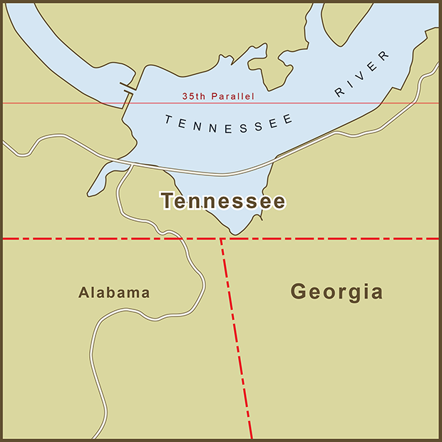
The original border between the two states was supposed to be drawn along the 35th Parallel. The actual border that was staked out was about a mile south of the where it was supposed to be. Stories differ as to why this happened. One postulates that the line where the border should have been drawn was difficult terrain so the survey crew marked the line on more navigable land. I love stories of human error so this is the story I want to believe but this can't be the first time a crew had to mark a line across challenging terrain. The other theory attributes the mistake to a simple matter of instrument accuracy. Whatever the case, the border was staked out and a map was drawn with the border more or less where it lies today.

The error was eventually caught but by then the wrong border had been around long enough that it had become the accepted state line. The border issue is being raised now because Georgia has a water shortage. If the border had been drawn accurately, a small part of the Tennessee River would lie inside Georgia, giving it access to much more water than it has today. Atlanta is sometimes called, "The Las Vegas of the American Southeast" for its habit of living beyond its means when it comes to water.

Georgia politicians have made numerous attempts to resolve the border issue with Tennessee ("in the 1890s, 1905, 1915, 1922, 1941, 1947, 1971" and 2008 according to one source). But such a change would require approval from Congress and Tennessee... something that's unlikely to happen. Moving the border would solve Georgia's problems but would create new ones. A Washington Post article reported on two issues that Georgia does not seem to bring up in its proposal, "Not only would Georgia get a chunk of Chattanooga, but Mississippi would get a slice of Memphis."

Perhaps the best quote on the border issue came from a contemporary Georgia surveyor, Bart Crattle who said, "It's correct -- no matter how wrong it is."

Sources: Wikipedia , Washington Post , NY Times

Tags water, water-rights, human-error
1 Comment
Canada-USA, Northwest Angle Map.png

A Map of "The Northwest Angle" Border Between the USA and Canada

June 24, 2018

There is no dispute over this one, it's just your garden variety error. It stems from a bad map and a negotiated treaty between England and the United States.

The error created several unique geographic situations including,

the fact that it is the only section of the Continental U.S. Border that extends above the 49th parallel, the latitude that marks the majority of the US border with Canada. Even Maine, which optically appears further North on some projections remains south of the 49th Parallel.

it creates a situation where driving from one spot in the Minnesota to another spot in Minnesota requires a 63 mile drive into Canada and then back into the U.S. even though the two spots are just 18 miles apart as the crow flies.

It is one of only four places in the continental U.S. where a section of a state (other than an island) is disconnected from the rest of the state.

According to the Wikepedia entry,"The Treaty of Paris, concluded between the United States and Great Britain at the end of the American Revolutionary War, stated that the boundary between U.S. territory and the British possessions to the north would run "...through the Lake of the Woods to the northwestern most point thereof, and from thence on a due west course to the river Mississippi..."

That all sounds pretty simple and clear as far as border descriptions go. The only problem was that the line could extend West all the way to the Pacific Ocean and never run into the Mississippi River. The source of the Mississippi, Lake Itaska lies almost 150 miles south of where it was expected to be. The error started with the Mitchell Map, a map that was in widespread use at the time.

When the problem was corrected by the Anglo-American Convention of 1818 it created a chunk of land that is part of Minnesota but cut off from the rest of the state. That land is called, The Northwest Angle, or simply, "The Angle" by locals. It is sparsely populated and most of the land is under the stewardship of a local Indian tribe. The immigration and customs office for The Angle is actually a phone booth with a video phone in it.

Tags human-error
Comment

Latest Posts

Featured
Mar 22, 2020
A Map of the 'Southwick Jog' between Massachusetts and Connecticut
Mar 22, 2020
Mar 22, 2020
Jun 24, 2018
The Property Border in Seattle that was Forced to go Around Edith Macefield’s House
Jun 24, 2018
Jun 24, 2018
Jun 24, 2018
The strange, slavery-defined border of Oklahoma’s Panhandle
Jun 24, 2018
Jun 24, 2018
Jun 24, 2018
Entrepreneurial Strangeness, A Map of the French-Swiss Border at the Hotel Arbez
Jun 24, 2018
Jun 24, 2018
Jun 24, 2018
The Strange Border between Croatia and Serbia in Liberland
Jun 24, 2018
Jun 24, 2018
Jun 24, 2018
A Map of the Bir Tawil "Triangle" and Related Territory Dispute Between Egypt and the Sudan
Jun 24, 2018
Jun 24, 2018
Jun 24, 2018
A Map of the Louisiana / Mississippi State Border along the Mississippi River
Jun 24, 2018
Jun 24, 2018
Jun 24, 2018
A Map of the USA / Russia Border as it Passes Between the Diomede Islands
Jun 24, 2018
Jun 24, 2018
Jun 24, 2018
A Map of the Uganda / Kenya Border Dispute Over Migingo Island
Jun 24, 2018
Jun 24, 2018
Jun 24, 2018
A Map of the Slovenia / Croatia Border as it Passes Through the Middle of Restaurant Kalin in the Town of Bregana
Jun 24, 2018
Jun 24, 2018

All maps are copyright 2018 by Andy Proehl