• About
  • Work
  • Maps
  • Writing
  • Strange Borders
Menu

am proehl

  • About
  • Work
  • Maps
  • Writing
  • Strange Borders
Canada-Denmark, Hans Island Map.png

Border Dispute with a Sense of Humor - A Map of the Canada / Denmark Border at Hans Island

June 24, 2018

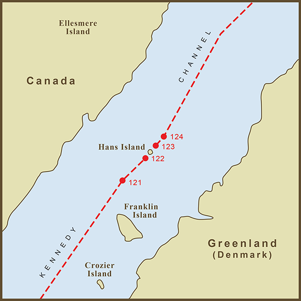
Hans Island lies smack in the middle of the Kennedy Channel section of Nares Strait. This places it on the border between Canada's Ellesmere Island and the Kingdom of Denmark's Greenland Territory.

In 1973, a treaty between the two nations plotted 127 points delimiting the agreed upon border. Although the treaty did not connect the dots, points 122 and 123 go right down the center of the island when connected.

Hans Island appears to be of little strategic or commercial interest but this has never stopped nations from starting a tug of war over sovereignty. Luckily, even though there are real emotions, the actions seem to be light hearted, if not satirical.

In 1984, Denmark's Minister of Greenland planted a Danish Flag on the island along with a bottle of cognac.

Canada responded with newspaper headlines announcing, "Canada being invaded" and "Denmark massing troops on Canadian Territory"

Google War - In 2005, a "Google War" was started with individuals from both countries placing ads on Google declaring Hans Island as Canadian or Danish territory.

The ads are no longer live but a Google search today turned up links for, "The Hans Island Liberation Front", "Hands off Hans Island", "Radio Free Hans Island", and the "Free Hans Island from Canadian Oppression" website. The last link is a fun read.

It's nice to see a lingering border dispute happen with a sense of humor.

Tags water, funny
Comment
Finland-Sweden, Market Island Map.png

A Map of the Strange Border Between Sweden and Finland on Märket Fyr

June 24, 2018

How did I not hear about this border sooner. An island less than 1200 feet long with a border that takes more twists and turns than a Stieg Larsson novel. It is now possible to walk the length of this short island and cross an international border three times. However, despite the strangeness of the border, Sweden and Finland have always agreed on shared ownership of the skerry (a Norse word for rock in the sea) and the serpentine border results from an effort to correct Finland's accidental siting of the island's lighthouse on the Swedish side of the border. The island is otherwise a textbook example of international cooperation and agreement.

Market Island or Reef (Market Fyr in Swedish) is part of the larger Aland Island chain that lies between Sweden and Finland. According to Wikipedia, ownership of the islands has been shared ever since the Treaty of Fredrikshamn in 1809. Prior to the building of the lighthouse, the border between the two countries passed down the middle of the skerry so that half the island's land mass was in Sweden and half was in Finland. When it was discovered that Finland had accidentally built the lighthouse on Sweden's half of the island, a fix was necessary. The resulting zig-zag border allows the lighthouse to be in Finland while retaining the 50/50 split in land area and avoids any changes to the maritime border. Any alterations of that would have resulted in a change in fishing rights… Perhaps the one thing that might have caused strife between the two herring-loving nations. Phew.

Tags island, funny
Comment

Latest Posts

Featured
Mar 22, 2020
A Map of the 'Southwick Jog' between Massachusetts and Connecticut
Mar 22, 2020
Mar 22, 2020
Jun 24, 2018
The Property Border in Seattle that was Forced to go Around Edith Macefield’s House
Jun 24, 2018
Jun 24, 2018
Jun 24, 2018
The strange, slavery-defined border of Oklahoma’s Panhandle
Jun 24, 2018
Jun 24, 2018
Jun 24, 2018
Entrepreneurial Strangeness, A Map of the French-Swiss Border at the Hotel Arbez
Jun 24, 2018
Jun 24, 2018
Jun 24, 2018
The Strange Border between Croatia and Serbia in Liberland
Jun 24, 2018
Jun 24, 2018
Jun 24, 2018
A Map of the Bir Tawil "Triangle" and Related Territory Dispute Between Egypt and the Sudan
Jun 24, 2018
Jun 24, 2018
Jun 24, 2018
A Map of the Louisiana / Mississippi State Border along the Mississippi River
Jun 24, 2018
Jun 24, 2018
Jun 24, 2018
A Map of the USA / Russia Border as it Passes Between the Diomede Islands
Jun 24, 2018
Jun 24, 2018
Jun 24, 2018
A Map of the Uganda / Kenya Border Dispute Over Migingo Island
Jun 24, 2018
Jun 24, 2018
Jun 24, 2018
A Map of the Slovenia / Croatia Border as it Passes Through the Middle of Restaurant Kalin in the Town of Bregana
Jun 24, 2018
Jun 24, 2018

All maps are copyright 2018 by Andy Proehl