• About
  • Work
  • Maps
  • Writing
  • Strange Borders
Menu

am proehl

  • About
  • Work
  • Maps
  • Writing
  • Strange Borders
Belgium-Netherlands, Baarle Nassau Map.png

A Map of the very strange borders between the Netherlands and Belgium at Baarle-Nassau

June 24, 2018

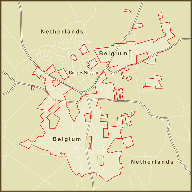
Without going into excruciating detail about allegiances to dukes, lords and kings, it is hard to explain the origin if this rather unique set of international borders. Suffice it to say that the land was bought, sold, and loaned through many generations to the point where the current land owners felt allegiance to either the Dutch or Belgian side of the border. When it came time to make the border official as art of the 1843 Treaty of Maastricht, 5732 separate parcels of land had to have their nationality laid down separately.

Fortunately the borders are all friendly. In fact, there were several opportunities to clean things up in subsequent treaties and negotiations that the residents refused to act on. The residents of Baarle-Nassau seem to enjoy their quirky borders and the ramifications they present.

There is at least one border line that passes directly through a building. With borders sometimes passing through the middle of properties, taxes were sometimes a challenge in the area. To clarify matters, the Dutch government set the rule that taxes would be paid to the country your front door opened up on. With taxes being higher on one side of the border than the other, the ruling was an invitation for creative renovations. If shop keepers didn't like the taxes they were paying, they were known to just move their front door so that it opened on the other country.

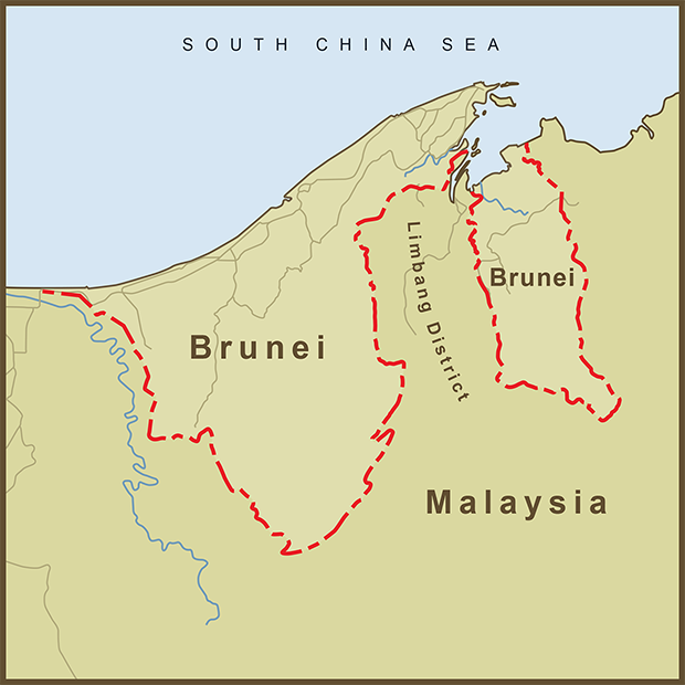
The primary border between the two countries lies about 5 kilometers south of Baarle-Nassau... just a short distance beyond the bottom of this map. What is truly unique about this set of borders is that it happens completely inside the Netherlands border. These are Belgian exclaves inside the Netherlands. But even more amazing is that there are Dutch exclaves completely inside the Belgian exclaves. The smallest plot, identified as H12 is just 28,331 square feet (a bit more than 1/2 an acre) in size. With all of the dysfunction between Israel and the Palestinians over land swaps, it is nice to see two countries getting along so well that there's no need to swap.

Sources: University of Buffalo , Wikipedia

Tags exclaves
Comment

A Map of the Border between Malawi and Mozambique Near the Islands of Likoma and Chizumulu

June 24, 2018

I was browsing through a list of exclaves around the world when I happened upon these two islands in Eastern Africa. The islands are Malawian territory but sit entirely within Mozambique's territorial waters. I am shocked at the lack of drama behind some strange borders and these two islands appear to be no exception. Most of the history behind the border can be traced to the explorer, David Livingstone's explorations in the region and the establishment of the, "Universities Mission to Central Africa" Station on the Island of Likoma.

Upon reaching Lake Malawi in 1859, Livingstone named it Lake Nyasa. As the British began to colonize the African continent, they eventually claimed all of the territory surrounding the lake and named it Nyasaland. Portugal then colonized the Eastern shore of the lake. Since the British still had their mission station on Likoma Island, the islands were given to Malawi when the final borders were drawn up.

Although ownership of the islands is not under dispute, the name of the lake is. Malawi obviously prefers "Lake Malawi". Most other nearby nations prefer "Lake Nyasa". According to Wikipedia, the name Nyasa came about from a mistake in translation. Upon arriving at the Lake, David Livingstone reportedly asked his guide for the name of the lake. The word that came back was "Nyasa". However, nyasa basically meant "lake," the generic word not the lake's proper name (if it had one). Lake Nyasa stuck but should really be translated as "Lake Lake" in other languages. I have seen this happen many times when researching the history behind a place name for my maps. Many of the names for native peoples are the result of this type of confusion between a local population and foreign explorers.

Tags exclaves, island
Comment
Austria-Germany, Town of Jungholz.png

A Map of the Strange Border and Banking Policies Between Austria and Germany around Jungholz

June 24, 2018

There is no shortage of interesting exclaves around the world and Jungholz does not disappoint. Like many other European exclaves, Jungholz owes its origins to Germany's Feudal era. Jungholz lies in a valley in the Alps. Once a German farmstead, it was sold to a new owner in what would eventually become Austria in 1342. Its location, completely surrounded by Germany was overlooked and eventually accepted as fact. There are no direct roads from Austria proper to Jungholz. By car, you must leave Austria, travel through Germany and then re-enter Austria in order to get to Jungholz. Accommodations have been made to ease the situation by giving Jungholz two area codes and two postal addresses, one German and one Austrian.

Perhaps the most interesting "dividend" of Jungholz's unique location is its banking rules. It has three German banks that operate a bit like their Cayman Island counterparts… off-shore banking without all the sand between your toes. As German banks operating inside Jungholz's tax-free status they offer the ability to transfer money to and from other German banks without incurring any fees. And since they operate inside of Austria, they are allowed to provide the cover of Austria's confidential banking laws which are second only to Switzerland's. One bank even has a James Bond-inspired bank product called, Goldfinger. According to an article on the Travel Intelligence website, the Reiffeisenbank offers the following reassurance to the prospective customer, “There are moments in life when you can’t compromise on confidentiality - for instance, when it comes to your money. Our Goldfinger Numbered Account makes absolute confidentiality a reality.”

Geographic isolation has its privileges.

Sources: Travel Intelligence , Wikipedia

Tags exclaves, long-drives
Comment

A Map of the Exclaves of Uzbekistan and Tajikistan in Kyrgyzstan

June 24, 2018

Although most of my map research focuses on the geography or history of an area, I often stumble on other topics of interest. In this case, it was the strategy of "Divide et Impera" (Divide and Rule) and how this strange set of exclaves relates to Joseph Stalin, James Madison and contemporary USA politics.

Under the former Soviet Union - Kyrgyzstan, Uzbekistan and Tajikistan were all united despite being composed of a number of different ethnic groups and regions. Today's exclaves are a holdover from the Soviet days when Stalin sought to keep the various factions in the area at bay by implementing "divide et impera". The strategy is essentially the same as "divide and conquer." and includes getting local rulers to turn against each other in order to distract them from their conqueror. Another technique is to introduce impediments that divert local resources that could otherwise be used for military revolt. This seems to have been the case here. Farmers living in an exclave who want to sell their crops must deal with hostile border guards, extra transportation costs and tariffs in order to sell their crops back in the mother country. Exclaves are a formidable tool in the divide and rule arsenal.

The exclaves became official in 1991 with the breakup of the Soviet Union. To keep the map simple, I focused on these five exclaves, four belonging to Uzbekistan and one belonging to Tajikistan. There as many as four more in this region, the Fergana Valley, described by "Chirol" in the Coming Anarchy as, "a virtual archipelago of enclaves". Two of the exclaves are little more than a square kilometer in size and hard to find on many maps. One is described as "the immediate area surrounding a train station". Another might have no inhabitants.

Caesar, Stalin, and Napoleon all made use of divide et impera in their various conquests. Research on the topic led to references to James Madison's 'Federalist Paper No. 10' written in support of the US Constitution (and against the potential for independent states to implement defacto divide and conquer strategies. Madison believed that a strong federal government was key to overcoming the problems of independent factions arguing for their own interests at the expense of others. No. 10 is considered by many to be the most important and influential of the Federalist Papers. According to the Wikipedia entry "Madison argued that a strong, big republic would be a better guard against those dangers than smaller republics". This is a debate that continues today.

During the American Civil War, the South's stated position was not in favor of slavery but in favor of the States' rights to choose. At the end of the day, it was about slavery but arguing for the right of each state to decide on its own is classic "divide and conquer" behavior. This strategy, intentional or not, continues today on topics like healthcare and immigration policy. These are difficult issues. Local control often satisfies local opinions but can keeps an issue from being fully resolved and has the potential to create enclaves of policy.

Sources: The Economist , Webs.com , Wikipedia , Caravanistan

Tags exclaves
Comment

A Map of Brunei and its Strange Border with Malaysia

June 24, 2018

Brunei (officially the, "Nation of Brunei, the Abode of Peace") is a surprisingly successful and stable states despite its apparent tenuous geography. It is surrounded by Malaysia and separated into two, disconnected states by Malaysia's Limbang District. Brunei occupies just one percent of the island of Borneo that it shares with the countries of Malaysia, and Indonesia. Despite its small size, it has a per capita GDP in the top ten of countries worldwide.

Brunei owes its split existence to the colonial era. It was once a much larger empire that extended beyond the shores of Borneo. Starting in the 1800s, it lost territory to colonial powers and James Brooke, a British citizen who became the first of the "White Rajas" of Sarawak. Brooke was given control of the Limbang District among other territories that eventually became part of Malaysia. In 1888, The "Abode of Peace" agreed to become a British protectorate and stayed that way for a hundred years. It regained it's independence from the United Kingdom in 1984.

Although the Limbang District is connected to the rest of Malaysia, it's roads are not. The only way to drive from the Limbang District to the rest of Malaysia is to drive across the border into Brunei and then across Brunei back into Malaysia.

Countries have come to blows over much smaller parcels of land. I have covered some in this blog. But I always wonder when I see something like Brunei's divided existence, why they couldn't do a land swap or reach some agreement that would have allowed Brunei to exist as a single entity and allowed the people of Limbang to drive across their country without first having to leave it.

Sources: Wikipedia

Tags exclaves
1 Comment
Oman-UAE, Exclave Map.png

A Map of the United Arab Emirates Exclave Inside the Oman Exclave Inside the United Arab Emirates

June 24, 2018

"Good Fences make good neighbors"

"Something there is that doesn't like a wall". – Robert Frost, 'Mending Wall'

My primary focus on this blog is the many interesting stories behind the borders we see today. But there was a time when borders did not exist and not everyone wants them when they're drawn. This is often the case with regards to nomadic people around the Word. It is also a big part of the history of borders on the Arabian Peninsula including this unique set of borders within the UAE.

Peter Easton, a commenter on a couple of my maps, has spent time in the region, including Oman, working on water issues. He understands the history and tribal dynamics well and shared the following insights,

"Historically there were no borders, and no concept of nation states. Allegiance was to a tribe and its head sheikh. This could be fluid, with tribes or sheikhs switching allegiances from time to time. Thus, to some extent, modern borders represent a snap shot of allegiances at a given time. The reason for an allegiance was complex. It could be based on family or tribal ties, on religion (with Islam having various sub-sects), on bribery, etc. When a group switched allegiance, its 'territory' went with it. The boundary of a group's territory was also dependent on various factors: where their oases was, where a vital water well was, where their goats and camels preferred to graze, location of historical burial grounds, etc, etc. The idea of a border as a line was quite meaningless. The land of the desert and mountains had no value to anyone except the local tribes. On older Arabian maps, you will often see no lines or just dotted lines. But this all changed when oil was discovered. Suddenly the precise location of a border line became very political and valuable."

By definition, the United Arab Emirates (UAE) is a collection of separate emirates into a single country. Each emirate is itself a composition of smaller regions with roots in the Arabian Peninsula's tribal era. Oman, a separate country from the UAE is itself separated into two large areas by the UAE. The Oman exclave has existed for some time but the UAE enclave within it appears to be a recent development. There is a village called Nahwa that sits just inside the UAE enclave. The whole region is mountainous and appears quite desolate so I had trouble seeing the "logic" behind the border on satellite imagery. At some point, the Sheikh of Nahwa probably switched his allegiance from Oman to the UAE and the outline of the exclave relates to the extent of the tribe's territory.

In an area where water is scarce, oases bound tribes to an area. It was also the search for more water that led to the discovery of oil on the Arabian Peninsula. Finally, it was oil that solidified so many borders here and around the world and led to strange ones like this.

Sources: Wikipedia

Tags exclaves
1 Comment
Bronx-Manhattan, Marble Hill Map.png

A Map of the Strange Border between Manhattan and the Bronx

June 24, 2018

Whenever I see a strange border like this, the bonus section always seems to belong to the more powerful of the two neighbors. Marble Hill is technically part of Manhattan even though it is now connected to the Bronx and separated from Manhattan by the Harlem River. If the Bronx was the more dominant player, I wonder whether the border would now follow a more egalitarian course.

When the Dutch first settled Manhattan, they called the area where the Harlem River emptied into the Hudson River, “Spuyten Duyvil”, the spouting devil due to its treachorous currents. The area contained shallow shoals and a tricky section of the Harlem River that curved around Marble Hill. It was hard to navigate in small boats let alone the steamships that plied these waters in the latter half of the 1800’s. So, in 1890, work was started on the Harlem River Ship Canal which cut off the need to go around Marble Hill. The former course of the river was then filled in to connect it to the rest of the Bronx. As a result, Marble Hill went from being part of the island of Manhattan, to being its own island, to finally being part of the Bronx. The border around Marble Hill follows the course of the former river. 

Sources: Wikipedia

Tags exclaves
Comment
Bangladesh-India, Dahala Khagrabari Exclave.png

A Map of the Dahala Khagrabari enclave inside a Bangladesh enclave which sits inside of India

June 24, 2018

This tiny slice of India is a small field owned by a farmer who lives in the surrounding Bangladeshi town. According to Wikipedia, the field is, “the world's one and only 3rd order enclave (a piece of India inside a piece of Bangladesh inside a piece of India inside a piece of Bangladesh).” There are a total of 106 Indian exclaves inside Bangladesh and 92 of Bangladesh that sit inside India.

As with other exclaves I’ve covered in the third world, they are cartographic curiosities but anything but fun for the residents. According to the Wikipedia article, "Residents of the exclaves generally live in miserable conditions, lacking access to basic services such as healthcare or electricity. These are not provided by their own government, as they are isolated from it by a strip of foreign land; nor are they provided by the surrounding state. They cannot visit their own country without crossing the international border surrounding the territory (enclave).”

Sources: Google Maps ,  Wikipedia

Tags exclaves
Comment

Latest Posts

Featured
Mar 22, 2020
A Map of the 'Southwick Jog' between Massachusetts and Connecticut
Mar 22, 2020
Mar 22, 2020
Jun 24, 2018
The Property Border in Seattle that was Forced to go Around Edith Macefield’s House
Jun 24, 2018
Jun 24, 2018
Jun 24, 2018
The strange, slavery-defined border of Oklahoma’s Panhandle
Jun 24, 2018
Jun 24, 2018
Jun 24, 2018
Entrepreneurial Strangeness, A Map of the French-Swiss Border at the Hotel Arbez
Jun 24, 2018
Jun 24, 2018
Jun 24, 2018
The Strange Border between Croatia and Serbia in Liberland
Jun 24, 2018
Jun 24, 2018
Jun 24, 2018
A Map of the Bir Tawil "Triangle" and Related Territory Dispute Between Egypt and the Sudan
Jun 24, 2018
Jun 24, 2018
Jun 24, 2018
A Map of the Louisiana / Mississippi State Border along the Mississippi River
Jun 24, 2018
Jun 24, 2018
Jun 24, 2018
A Map of the USA / Russia Border as it Passes Between the Diomede Islands
Jun 24, 2018
Jun 24, 2018
Jun 24, 2018
A Map of the Uganda / Kenya Border Dispute Over Migingo Island
Jun 24, 2018
Jun 24, 2018
Jun 24, 2018
A Map of the Slovenia / Croatia Border as it Passes Through the Middle of Restaurant Kalin in the Town of Bregana
Jun 24, 2018
Jun 24, 2018

All maps are copyright 2018 by Andy Proehl