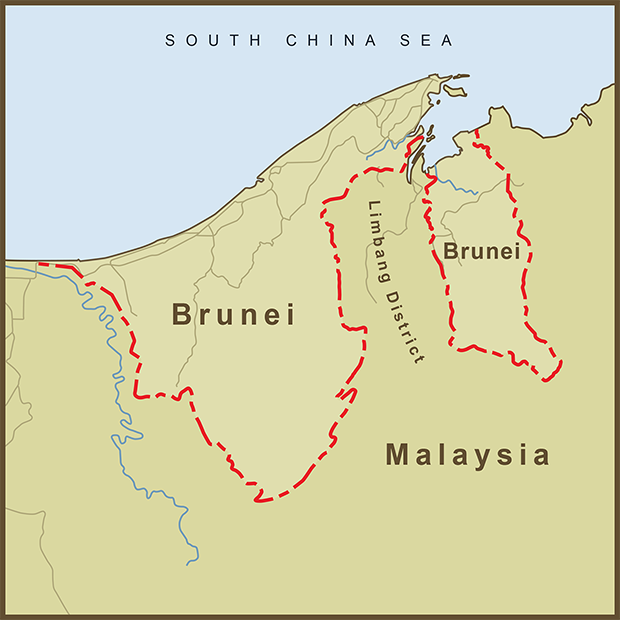
Brunei (officially the, "Nation of Brunei, the Abode of Peace") is a surprisingly successful and stable states despite its apparent tenuous geography. It is surrounded by Malaysia and separated into two, disconnected states by Malaysia's Limbang District. Brunei occupies just one percent of the island of Borneo that it shares with the countries of Malaysia, and Indonesia. Despite its small size, it has a per capita GDP in the top ten of countries worldwide.
Brunei owes its split existence to the colonial era. It was once a much larger empire that extended beyond the shores of Borneo. Starting in the 1800s, it lost territory to colonial powers and James Brooke, a British citizen who became the first of the "White Rajas" of Sarawak. Brooke was given control of the Limbang District among other territories that eventually became part of Malaysia. In 1888, The "Abode of Peace" agreed to become a British protectorate and stayed that way for a hundred years. It regained it's independence from the United Kingdom in 1984.
Although the Limbang District is connected to the rest of Malaysia, it's roads are not. The only way to drive from the Limbang District to the rest of Malaysia is to drive across the border into Brunei and then across Brunei back into Malaysia.
Countries have come to blows over much smaller parcels of land. I have covered some in this blog. But I always wonder when I see something like Brunei's divided existence, why they couldn't do a land swap or reach some agreement that would have allowed Brunei to exist as a single entity and allowed the people of Limbang to drive across their country without first having to leave it.
Sources: Wikipedia