• About
  • Work
  • Maps
  • Writing
  • Strange Borders
Menu

am proehl

  • About
  • Work
  • Maps
  • Writing
  • Strange Borders
Finland-Sweden, Green Zone Golf Course Map.png

The Strange Border between Sweden and Finland that Crosses a Golf Course

June 24, 2018

Play one round of golf at the Green Zone Golf Course and you get to do it in two countries. The course and the surrounding towns were built on the delta of the River Tornio which also marked the border between Sweden and Finland. The original settlement was the nearby town of Tornio. It was in Finland but was largely settled by Swedish speaking merchants. When Sweden ceded Finland to Russia in 1809, many of the Swedish speaking residents migrated across the border to Sweden and created the new town of Haparanda. The two towns have always remained friendly and now promote themselves as a single, border-spanning economic zone. The golf course symbolizes the borderless ambitions of the two cities.

Despite all the friendly relations between the two towns, Sweden and Finland actually lie in two different time zones. This makes for some strange experiences. Residents often celebrate New Year’s Eve twice the same night. And on at least one border-straddling hole on the golf course, your ball will land an hour after you hit it.

Sources: Basement Geographer , Wikipedia , Google Maps

Comment
Presidio-SF, Juana Briones Map.png

Map of Strange Border in the Presidio thanks to the industrious and take-charge attitude of Juana Briones

June 24, 2018

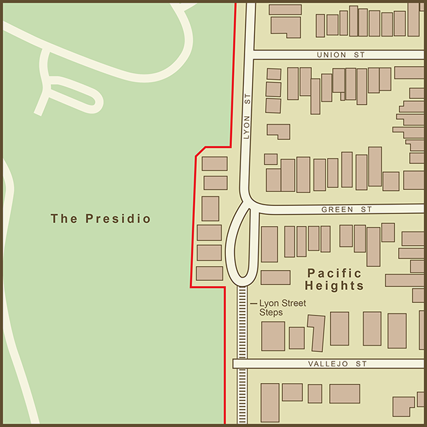
The compromise in this otherwise rigidly-straight former military border is thanks to an amazing woman and early San Francisco pioneer named Juana Briones. I'm embarrassed to admit that I wasn't aware of her sooner given my interest in San Francisco history and having run the nearby Lyon Street Steps many times when I lived in the neighborhood.

Juana Briones was born in Santa Cruz of Mexican-born parents in 1802. She grew among the Native American Indian tribes and learned about healing and natural herbs from them. A skill that became part of her identity. The family then moved to San Francisco in 1812 and took up residence inside the Presidio which was then more of a fortified village than strict military base. They lived in a small community next a spring known as El Polin above what is now Tennessee Hollow. In 1820, she married a military calvaryman and together, the couple built a new house on the border of the Presidio at another spring known as El Ojo de Agua Figueroa. That location is the setting for this map. It soon became clear that her husband was an abusive drunk and Juana started plans to leave him and gain her own financial independence. She built another adobe house near present day North Beach. She was among the first westerners to settle there in Yerba Buena (what would become San Francisco). Juana would eventually acquire multiple ranches and properties in the area of Palo Alto. By the time California became US Territory in 1848, she had the means and the good judgement to hire a top lawyer to represent her interests with the newly installed US government. This allowed her to retain ownership of her properties including the house at El Ojo de Agua Figueroa. That house straddled the border between the military base and the rest of San Francisco. Juana now having official title, the military had little to do but alter the border to go around her property.

The wall separating the base from San Francisco is still there but no longer guarded. The Presidio is now part of the National Park System. Juana Briones' house is long gone, replaced by 6 mansions in today’s Lower Pacific Heights. The El Ojo de Agua Figueroa spring no longer flows but the strange border created by this bright, independent and pioneering woman remains. A sign that even an army and the US Government are no match for the will of a woman bent on controlling her destiny.

Sources: Stanford University , National Park Service

Comment
Bangladesh-India, Dahala Khagrabari Exclave.png

A Map of the Dahala Khagrabari enclave inside a Bangladesh enclave which sits inside of India

June 24, 2018

This tiny slice of India is a small field owned by a farmer who lives in the surrounding Bangladeshi town. According to Wikipedia, the field is, “the world's one and only 3rd order enclave (a piece of India inside a piece of Bangladesh inside a piece of India inside a piece of Bangladesh).” There are a total of 106 Indian exclaves inside Bangladesh and 92 of Bangladesh that sit inside India.

As with other exclaves I’ve covered in the third world, they are cartographic curiosities but anything but fun for the residents. According to the Wikipedia article, "Residents of the exclaves generally live in miserable conditions, lacking access to basic services such as healthcare or electricity. These are not provided by their own government, as they are isolated from it by a strip of foreign land; nor are they provided by the surrounding state. They cannot visit their own country without crossing the international border surrounding the territory (enclave).”

Sources: Google Maps ,  Wikipedia

Tags exclaves
Comment
← Newer Posts

Latest Posts

Featured
Mar 22, 2020
A Map of the 'Southwick Jog' between Massachusetts and Connecticut
Mar 22, 2020
Mar 22, 2020
Jun 24, 2018
The Property Border in Seattle that was Forced to go Around Edith Macefield’s House
Jun 24, 2018
Jun 24, 2018
Jun 24, 2018
The strange, slavery-defined border of Oklahoma’s Panhandle
Jun 24, 2018
Jun 24, 2018
Jun 24, 2018
Entrepreneurial Strangeness, A Map of the French-Swiss Border at the Hotel Arbez
Jun 24, 2018
Jun 24, 2018
Jun 24, 2018
The Strange Border between Croatia and Serbia in Liberland
Jun 24, 2018
Jun 24, 2018
Jun 24, 2018
A Map of the Bir Tawil "Triangle" and Related Territory Dispute Between Egypt and the Sudan
Jun 24, 2018
Jun 24, 2018
Jun 24, 2018
A Map of the Louisiana / Mississippi State Border along the Mississippi River
Jun 24, 2018
Jun 24, 2018
Jun 24, 2018
A Map of the USA / Russia Border as it Passes Between the Diomede Islands
Jun 24, 2018
Jun 24, 2018
Jun 24, 2018
A Map of the Uganda / Kenya Border Dispute Over Migingo Island
Jun 24, 2018
Jun 24, 2018
Jun 24, 2018
A Map of the Slovenia / Croatia Border as it Passes Through the Middle of Restaurant Kalin in the Town of Bregana
Jun 24, 2018
Jun 24, 2018

All maps are copyright 2018 by Andy Proehl