My early map efforts used traditional maps as an inspiration. There are so many details I admire in old maps. Most of all, I love the long descriptive and decorative typographic titles. My traditional-looking maps are also an attempt to create portraits of a particular place. Some, like the lost towns of Monticello, CA and Kensico, NY are based on personal interest. Others are just travel journals of places I’ve visited.
The Misool Eco Resort is a dive resort in a remote part of Raja Ampat, south of West Papua, Indonesia. After visiting there in September 2019, I was inspired to create this map. The resort occupies a small part of a small island in a vast archipelago in the Ceram Sea. But it is supported by the large and inspiring effort of the Misool Foundation and the local Misool community. The area was once over fished with devastating impact on the local reefs. The resort beach was once a shark finning camp. The founders, Andrew and Marit Miners witnessed the devastation but also saw the potential to restore and preserve the area for the benefit of the community and eco-conscious divers. Their efforts now include the lease of a large “No Take Zone” within which many of the dive sites sit. All of the dive guides and staff are local and the foundation employs rangers to patrol the area against illegal fishing. They’ve even started a recycling plant to manage trash collection for the community. The entire resort was built with local, reclaimed wood and is powered as much as possible by solar power. The scope of the effort is deeply inspiring.
Inspired as I was, I made this map. My go to source for maps is usually Google Maps. But the area is so remote that the islands were rough misshaped blobs of what is actually there. So I started with satellite images and and redrew every island, rock and reef. Working from a reference map at the resort I then added all of the dive sites. Raja Ampat, part of the “Coral Triangle”, features an incredible diversity of sea life. This includes giant majestic Oceanic Manta Rays some of which exceed six meters across. An illustration I made of a manta ray we observed at the aptly named “Magic Mountain” became the map’s mascot.
Every map presents a challenge in visual story telling. For this map, my challenge was how to show the shallow, turquoise water associated with the reefs and dive sites that surround many of the islands. In particular how do I juxtapose the turquoise color next to the pale blue of the surrounding open ocean. These two colors clash when placed next to each other. One way would have been to make the open ocean a deep, dark blue but that would have dominated the map and made text labels difficult. I also wanted an overall light palette for the map. The solution I finally arrived at was outlining the reefs in a darker blend of the two colors. It creates a clear visual edge to the reefs while letting me keep the open ocean a light blue. The Olibi Islands detail shows the effect up close.
Point Reyes and the adjoining Tomales Bay is one of my favorite areas in the San Francisco Bay Area. Point Reyes has great hiking and kayaking Tomales Bay can be beautiful before the wind comes up.
This map has a more traditional look which hides it's unique perspective. I wanted to create a basic map that highlights the major towns and landmarks. The key difference between this map and other maps of the area is the map's orientation. The map is rotated clockwise about 35 degrees. I did this because it is closer to your actual experience of the area. The general orientation of the California coast is North South even though it veers in and out quite a bit. Driving up Highway 1 in the area feels like you're driving North with the Pacific Ocean to your West. As it nears Point Reyes, Highway 1 also follows the San Andreas Fault and the fault is key to what makes Point Reyes unique. Land on the ocean-side of the fault sits on the Pacific tectonic plate while the mainland-side is part of the North American Plate. As the two plates grind past each other, Point Reyes moves North. The land mass moved 16 feet almost instantly in the 1906 Earthquake.
All of this made me want to orient Highway 1 vertically and visualize Point Reyes as a mass of land sticking out into the Pacific. Tomales Bay, Highway 1 and the San Andreas Fault all align vertically to reinforce the image I have in my head when I'm there. It also serves to capture the area as something unique and slightly removed from the surrounding area.
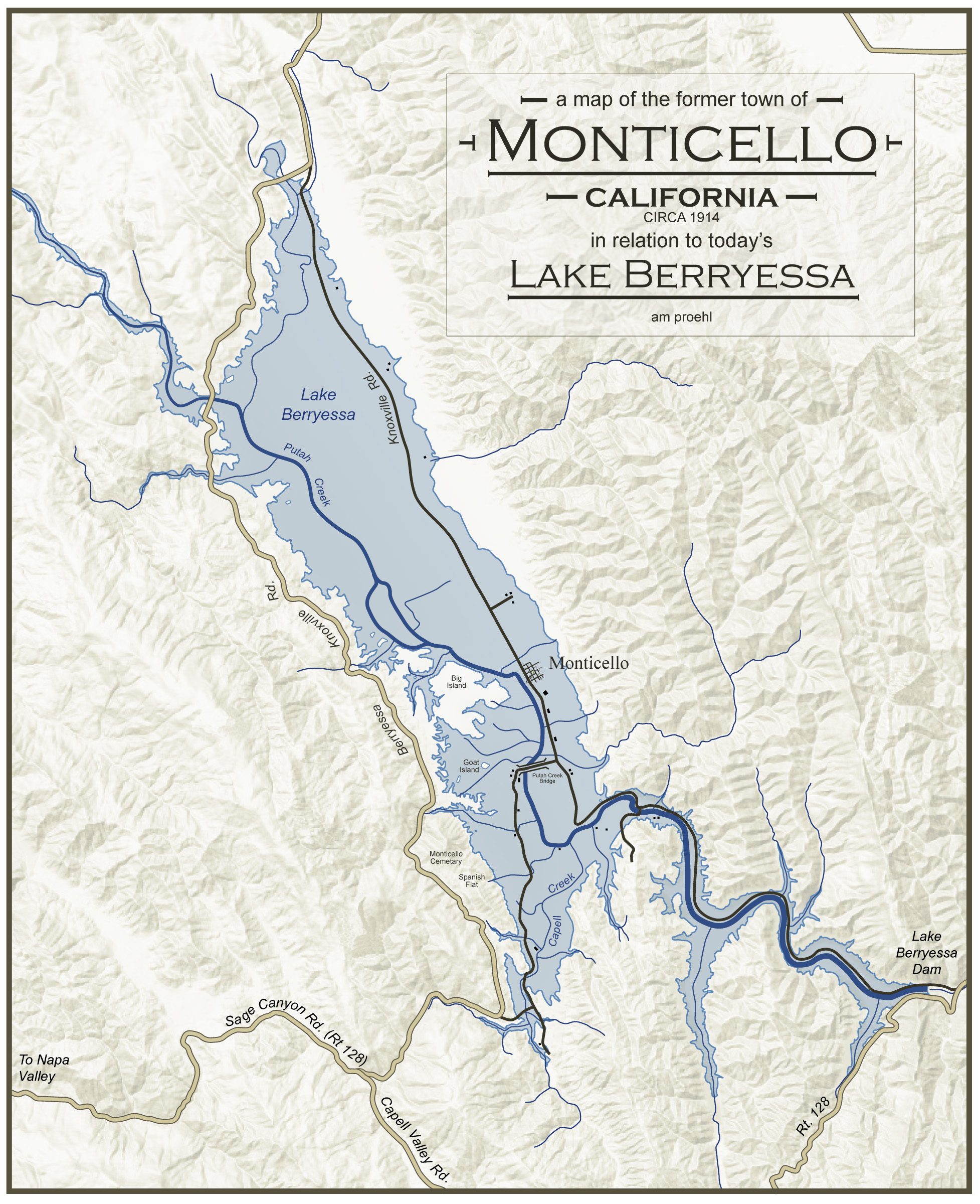
Where Lake Berryessa now stands there once was a fertile valley full of farms, orchards and the small town of Monticello, California. Before Monticello there were the Adobe buildings that were part of the Mexican-owned Rancho de Los Putahs. And before the Spanish arrived, there was the Patwin village of Topaidihi. All of this is now lost below the waters of Lake Berryessa.
Berryessa comes from the Basque family name of the early Spanish settlers of the valley (Berelleza was the likely original spelling).
Berryessa Valley as it came to be known, was first settled by the Patwin and Pomo Indians who lived there for thousands of years. A 1948 archaeological survey of the valley found the remains of approximately 150 Native American villages. They lived easily off the abundant trees, plants, and animals of the valley and surrounding hills. According to ome history, bears roamed the hills and, over time, created trails that were later used by the Berreyesa family to get their cattle up and over the mountains and into the valley.
The first Spanish settler in the valley was Nicolas Antonio Berreyesa who was born in 1761 in Sinaloa Mexico of Spanish parents. He arrived in Northern California as part of the 1776 De Anza Colonization Expedition. In 1779, Nicolas married the daughter of Gabriel Peralta, one of Anza’s soldiers. They had nine children together including, Nasario Antonio who would eventually establish the first ranch in Berryessa Valley.
Two of Nasario's sons, Sisto and Antonia, were in the Mexican Army and based in San Francisco. In 1838 they married the Higuerra twins, Nicholasa and Maria Anatasia and moved up to their father's rancho in the valley a short time later. In 1843, the two sons became the official owners of what came to be known as Rancho de la Putas through a Mexican land grant.
There are several possible origins regarding use of the word Putas in the rancho name. One is that the local Patwin tribes engaged in "licentious behavior" and the river became known as the Rio de los Putos (putah being the word for prostitute in Spanish). Another version says that the name evolved from, "puta wuwwe" (grassy creek), the Miwok name for the creek. In that telling, any similarity to the Spanish "putah" was coincidental. I tend to believe the latter as while they may have used an unflattering name for the Indians and the creek, it seems less likely that they would intentionally name their ranch, Ranch of the Prostitutes.
By 1866, most of the original Berryessa family had died, been killed, or had sold the land to pay off family debts. Most of this seems associated with the transition of California from Mexican to U.S. territory. Knowing the valley's reputation as perhaps the most fertile in the country, developers bought up the land and cut it up into many small plots. A year later, the valley was full of productive farms.
The town of Monticello was established shortly thereafter. A hotel was then built as a stopover point for the stagecoach that ran between Napa and a large mining operation in Knoxville, north of the valley. Monticello was known for it's annual rodeo that had grew out of a tradition at one of the valley ranches.
Although the farms and orchards of the valley thrived, discussions of building a dam and flooding the valley occurred as early as 1906. It became official in 1954 under President Eisenhower and construction started the same year. The residents of the town and valley tried to fight the movement but were unsuccessful. Life Magazine sent Dorothea Lange to document their plight but never published the photos or story. The town was bought up and leveled. The town cemetery was dug up and moved to Spanish Flat in the hills just West of the lake. There is also a small museum in Spanish Flat that was created by surviving family members with a number if photos and artifacts from Monticello.
In one of the historical accounts I read, a local farmer was quoted as saying, "they took our land away like we were Indians." I'm not sure he was aware of the irony of his statement. Perhaps if the bears could talk, they would complain of their loss of habitat. The Indians have surely complained with rarely anyone willing to listen. History describes the Berryessa family as doing themselves in through gambling debts and the like but i doubt it was that simple. With the land changing from Mexican to American hands there were bound to be conflicts and new claims of dominion. Alas, not even the white man's land is safe in the evolving landscape now seemingly a picturesque, tranquil lake.
Sources: UC Davis , Bella Vista Ranch
I've always been fascinated that I-280 in Palo Alto goes over the top of a particle accelerator. It's not everyday that you can drive over the top of a Nobel Prize winning Physics Lab. I also find the curve of the highway against the accelerator's "straightest building on Earth" geometry interesting so I decided to make this map. As I was looking at the satellite images, I was intrigued by the chaos of buildings at the terminus (right side) of the accelerator. They almost look like they were the victim of a series of particle collisions themselves.
I made this map after as a record of our week in the Galapagos Islands aboard the Nemo III catamaran. It was an amazing trip in an amazing place so I started thinking about making a map while I was still on the trip.
D3js.org is an awesome, open source resource for data visualizations. A blog post by the D3 Team about their amazing map projections software included the ability to create your own custom map projection. So after trying a bunch, I settled on this one. It is inspired, in part by Buckminster Fuller’s Dymaxion Map. That map tries to show the Earth’s land mass as one giant island surrounded by a single ocean. This projection does much the same at the expense of having the South Pole split in half on the lower left and right corners. The Proehl Projection (a play on "Polar Projection”) is based on the D3 software but styled by me. Make your own projection here.
I first caught sight of the Sutter Buttes as I was driving back home from a weekend at Camp Okizu where my wife and I volunteer. We were coming down out of the Sierras east of Oroville when we saw them. They are a striking sight and have earned their nickname as "The Shortest Mountain Range in the World".
From a distance, they look like a razor-back linear ridge of mountains in the middle of nowhere. So I was surprised to see that they actually have quite a circular footprint. They are surrounded on all sizes for many miles by the completely flat farm land of California's Central Valley. This is what I wanted to capture in the map, rippled foothills and rough crags surrounded by the perfectly straight North-South, East-West roads that result when there is little to get in their way.
The land is mostly private ranch land but there have been talks to turn them into a State Park if the proper deals can be negotiated. The buttes were sacred to the indian tribes that once occupied the area and figure prominently into their creation myths. Their name for the buttes translates roughly into "Middle Mountain". I have yet to hike the buttes but organized hike are offered on a regular basis by several local non-profits including the Middle Mountain Foundation.
This map is another trip / journey map. In June of 2007, my wife and I climbed Mt. Kilimanjaro with 12 other people. It was a major undertaking and accomplishment for us so when we got back, I immediately started on a map. There are 3 or 4 major routes up the mountain so I wanted to understand our route relative to the others. People often ask me what map did I use as a base map. I have scans of all of my base maps and my finished maps usually bare little resemblance to my source maps. For my Kilimanjaro Map, I relied on a very cheap and poor tourist map that I bought at a hotel gift shop, some aerial photographs and a few map details that I found on the Internet. The trickiest part was figuring out how to render the mountain which is really a large cinder cone sitting on top of a giant volcanic dome. The dome appears quite smooth and regular from a distance so after several attempts at rendering more detail, I settled on some very simple blends and shading. I realized I could use the same technique to create an elevation view of the mountain so I added that in which gives a better sense of the scale of the mountain. In addition to the summit peak itself, there were two other major geographic features along our journey, Cathedral Spires and Mwenzi Peak. Seeing them in both the map and the elevation makes it easier to understand the various summit routes. There were also key landmarks on our journey so capturing them on the map was key. The map documents not just our route but dates and campsites as well as a few minor details such as the route taken by one of our climbers who got sick and had to hike out on Day 4. The cartouche contains a slightly personalized description of the mountain in the fine type. I also created a decorative border for this map based on a traditional African pattern... something I might try more of in future maps.
This is the map that got me into map making. In January 2000, I Googled the Town of Kensico, NY, a town that hasn't existed since 1915. I was surprised to see Google return a large number of links and it got me reading up on the former town. Kensico, NY was a small town about an hour North of New York City. It was purchased by the city and leveled to make room for a reservoir for the city's rapidly growing water needs. My Internet research eventually led me to a 19th century tax map of the town. As a boy I grew up just a couple of miles from the reservoir. There were local legends about the town including one untrue) that said that the steeple of the town's church would stick up out of the water when the reservoir was low. Although I had known about the town's existence, I never knew exactly where the town was. When I found the tax map, I used Photoshop to overlayed the tax map on top of a current Yahoo map of the reservoir and figured out where the town was. I then got a USGS topo map of the reservoir and the hills that surround it and used that to created a new digital map that shows the town and how its roads connected to today's roads outside the reservoir. I have a version in Adobe Illusrator with layers for the town and the reservoir. It enables me to dial the transparency up and down revealing or hiding the town.
My Kensico map partially inspired my Silk Road map. Both are places that no longer exist in the real world but live on vibrantly on the Internet.